Showing posts with label Glass Half Full. Show all posts

Monday, July 27, 2015

Wander Report: Day Summit of Mount Rogers, VA 7/26/15


It was time to make a second attempt at the summit of the tallest point of the state of Virginia. Just this past spring, we made plans to summit Mount Rogers and were met with 30 degree weather and 50 mph winds. We may have been able to tough it out that day if we did not have our 3 and 4 year old with us, but we were not necessarily prepared for the weather completely. Needless to say, we abandoned any thoughts of bagging this peak in those weather conditions.

Fast forward to July 26th. It was a hike date with my wife, Wander Woman that we were both looking forward to. No kids this time, so we could really up the mileage that we normally do as a family. We reached Grayson Highlands State Park at 10:00 AM to a very comfortable 72 degrees. The morning fog had just lifted to expose partly cloudy skies and there was a nice cool breeze blowing through the park.

We started from the parking area at Massie Gap, where we basically crossed the field to join the trail head for Rhododendron Trail. We passed through the gate and headed up the .8 mile trail. Almost immediately, we found ourselves surrounded by large blueberry bushes and blackberry bushes.

There is a crossroads at the end of this trail that lets you either take a connector trail to the Appalachian Trail (AT) or you can follow the bridal trail. Both lead you to the gate of the park boundary, but we decided to take the bridal trail on our way out. Either way it is only about .25 miles to the gate leading you out of the state park.

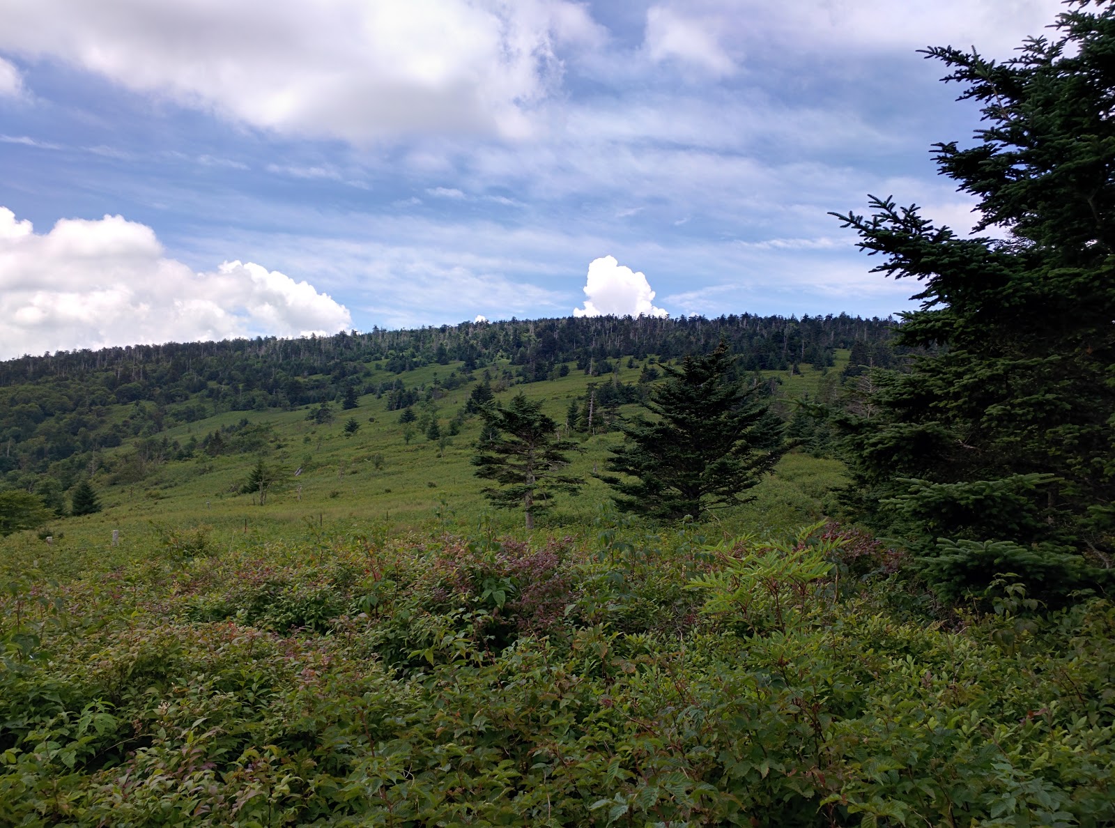
Once through the gate, we hiked south on the AT. It is very well marked in this area with white blazes. Quickly, we were navigating through the open balds on the rocky path of the AT. The views are absolutely stunning in this area and as we headed over the first pass we stopped to take in the view and chat with a Virginia Tech student that was up to film the wild ponies.

Unfortunately for him, if he had only hiked .25 - .5 miles further he would have met one of the herds of wild ponies that roam these balds. A mother and what appeared to be her colt were meandering along the trail, heads down, grazing on the grasses of the mountain. The mother actually looked pregnant to us, but I could not confirm this. Soon, the rest of the herd appeared and many more mothers with young ponies in tow. I have to say, it feels very different to hike into a herd of wild animals that are not spooked really when they see you. They didn't seem to mind us coming in close for photos, but I fear it is due to humans feeding them that they have become conditioned to us.

Pregnant?

One of the many young ponies we met on our trek.
After our romp with the wild ponies, we continued on the AT through Rhododendron Gap. You can take the Wilburn Ridge trail instead if you prefer more of a rock scramble. The Wilburn Ridge Trail joins back to the AT after about a mile.

This area of Rhododendron Gap offers more breathtaking views and I highly recommend climbing up the large pinnacle rock to get a panoramic view of the gorgeous landscape.

We followed the white blazes of the AT a while longer through the Crest Zone. A little more than 4 miles into the hike we came to the Thomas Knob Shelter. This was the perfect spot for a lunch break. I highly recommend going behind the shelter out onto the rocks for the best view. This is a pretty big shelter with a second floor that you can reach by ladder. There are also numerous surrounding areas that are obviously carved out by through hikers and over-nighters into perfect campsites. You can see a large grove of blueberry bushes that look to span miles from behind the shelter.


After a quick bite to eat, we continued on the AT for approximately .25 miles and met the Mount Rogers Spur Trail. Here, we left the AT and hiked the .5 miles to the summit of Mount Rogers. It is not a typical peak climb. Here you actually climb into the treeline instead of out of the treeline to a bald summit. It is almost magical when you leave the AT on this trail as you quickly enter a more rainforest-like atmosphere. Deep green hues provided by the moss and ferns on the ground. Numerous mushrooms cover the floor of this forest.

The false summit with arrow pointing towards the true summit.
At the summit, if you haven't done a little research you would easily miss the summit. There are two rock outcroppings about 100 feet from each other. Both have a USGS benchmark in the stone, but one has an arrow stamped into it pointing towards the other marker.

The true marker of the summit of Mount Rogers.


The summit does not provide panoramic views of the surrounding valleys and peaks. It is buried deep in the forest and does not resemble a typical peak of a mountain. Much less, the peak of the highest state point of Virginia.


The peak of Mount Rogers from below the treeline.
The only thing that could have made our trek better was if we did not have to come back down. But, the hike back to the car was just as invigorating as the climb up. We knew that we could see the wild ponies again. All of the gaps and peaks we climbed up to we could now appreciate the views as we made the descent.

Wandering Notes:

Distance = 10 miles according to my GPS tracker
Elevation Change = Around 1100 to 1200 feet
Difficulty = It is actually not a strenuous climb at all. The distance poses the biggest challenge for most. The rocks can be an obstacle for weak ankles, but not difficult to navigate at all. It is a good family hike with lots of great rest stops with beautiful scenery. We averaged a little less than 30 minutes per mile, but really took our time.
Grayson Highlands State Park = A beautiful park with trails, camping, equestrian stables, and a large picnic area that is top notch. Day parking is $4 on weekdays and $5 on weekends and holidays. Grayson Highlands State Park


Wander Woman


Trail register

Looking back into Grayson Highlands State Park after crossing out of the park's boundary

The bridal trail in Grayson Highlands State Park

Tuesday, July 21, 2015

The Best Part of the Adventure.


I love the outdoors. I love hiking. I love going down a river. I love climbing. I love rolling up and down a good single track on my bike. Am I an expert at any of these? Absolutely not. Do I own the best gear? No (Heck, in many cases I don't own any gear). But, my lack of expertise and/or top gear will never keep me from going on an adventure. What brings me back to do another adventure? The experience, the people and the memories - my family.

My parents were not what I consider outdoor enthusiasts when I was growing up, but they succeeded in planting a seed that continues to grow. In fact, I can only really remember one "outdoor" trip as a family to hike to the top of Mt. Leconte in Tennessee. It was with a group of the families in our neighborhood that had kids and we all hiked up and spent the night in the cabins at the top before hiking back down the next day. That was all it took to firmly plant the seed.

Earlier this year, I had a discussion with some of my friends about how disappointed I was in the amount of time that is devoted to computers, cell phones and tablets today. Of course, we all talked about how much we played outside as kids and that our current neighborhoods looked like ghost towns because all of the kids are always inside. I told them about how much my kids had enjoyed hiking with my wife and I (and how much we enjoyed them being with us). A couple of my friends mentioned they would enjoy going with us sometime.


Thus began the High Point Adventure Society. Our first trip had 5 adults and 5 kids. In 4 short months, we have grown. We had 12 adults and 9 kids (ages 2 mos. through 40+) at our last adventure. The foundation of our club is getting outside with our kids and families and being active while creating memories. It is hard to find something as rewarding as a walk in the woods with your family. Talking without distractions, watching them interact with the other kids, and learning what peaks their interest in nature will stay with me forever.

Now, don't get me wrong. I like to push my limits and head out for the multi-day adventures that may be a little advanced for the kids (ages 3 and 4), but my greatest thrill is invoking my passion for the outdoors into my children and experiencing the adventure with them. I will never tire of hearing "Dad, where are we going hiking this weekend?"


Tuesday, May 12, 2015

Boone Fork Trail - Julian Price Park 5/9/15

It is that time of year when the outdoors starts calling the family out of the house.


The High Point Adventure Society had their second outing this past week. Friends gathered at Julian Price Park in Blowing Rock just off the Blue Ridge Parkway to hike the Boone Fork Trail. The trail is a 4.9 mile loop that begins and ends in Julian Price Park. The weather was fantastic and the company even better!

Half of the group hiked clockwise and the other half set off in the opposite direction. My group hiked clockwise so that is how I describe this trail. The age difference of our participants ranged from 3 years old up to middle aged adults. 

The hike begins with a meander through the Julian Price campground before beginning the ascent up to the balds of the mountain. Here in certain spots you can catch a glimpse of Grandfather Mountain and it is a great spot for a picnic or just a break from the hike.


You quickly meet up with the Mountains to Sea Trail and shortly afterward the Tanawha Trail.


The green is really exploding in the North Carolina Mountains and at times it feels like walking in the rainforest. The canopy can be quite low at points (which can be tricky for the taller hikers).


The moss and rhododendron really give you a barrier from the rest of the park and allow you to lose yourself in nature.

Although, the hike is listed as strenuous by many trail guides, I would classify this as a more moderate trail. Obstacles are probably the reason for the strenuous rating (there is a short ladder about 3.5 miles into the hike), but it is an easy 3 hour day hike for most people. The shallow creek crossings can pose some problems for hikers. But for dog owners (dogs are allowed on the trail), they offer a nice relaxing soak to cool down.


The ladder

A very cool man-made bridge on the trail


The trail is very well marked with well manicured markers every half mile as pictured below and orange blazes throughout the trail on the trees.

In the last third of the hike, you have an option to make a short trek down the hill to view Hebron Falls. Hebron Falls, after a massive rock scramble, is a spectacular reminder of the beauty of the North Carolina mountains. Many of the people that were taking in the site were swimming at the base of the falls. The falls are a short hike from the Park entrance if you move counter clockwise on the loop.

Hebron Falls


The final portion of the trail leads you through the flood plains where you can see signs of Beaver and take in the sunshine as you come out of the tree canopy.


One of the many trail markers

Rainforest?


For more information click here Julian Price Park


Tuesday, April 14, 2015

Stone Mountain NC - Debut of the High Point Adventure Society

After getting rained out for our March event, the High Point Adventure Society had their inaugural hike on Saturday, April 11th. We met at Stone Mountain State Park in Roaring Gap, NC to tackle the 4.6 mile Stone Mountain Loop Trail.
4/11/15 High Point Adventure Society

The weather was perfect. Temps in the low to mid 50's to start with a high of 74 for the day. We hiked the trail clockwise starting at the upper trail head.

We followed the short connector trail from the parking lot to the trail head where we were met by a free standing chimney. As we made the turn left we did not have to hike far before we were greeted by the Stone Mountain Falls.

At the bottom of the falls


The trail turns into a long staircase the cruise right beside the waterfall all the way to the bottom. A LOT OF STAIRS. The bottom offers a nice gathering pool and access to the falls. Note: I would not recommend doing what the visitors in the background are attempting, Serious injury can happen.

The next 1.25 miles is a scenic meandering walk in the forest to a large open field that gives you the full view of Stone Mountain from the base. It also is the location for the Hutchinson Homestead.

"Hutchinson Homestead: Complete with a log cabin, barn, blacksmith shop, corncrib, meat house and original furnishings, visit this farm that was built in the mid-19th century. Restored in 1998, the homestead is representative of the lives of early settlers in the area." (from Stone Mountain State Park website)

The trees and flowers were just starting to bloom which provided beautiful scenery for us to stop and take in some lunch before we made the strenuous climb up to the summit. Lots of rhododendron throughout the hike and I am sure nice blooming flowers that we were too early in the season to see.

Hutchinson Homestead
The climb is not for the faint of heart and to be honest, was probably the limit we could do with our 3 and 4 year old. My wife carried our 3 year old to the top in the Ergo, but my 4 year old climbed like a champ.

It is a stout straight vertical climb with a mix of wooden man-made stairs and natural rock stairs. A good test to the cardiovascular system, but so worth it when you reach the top. The adults got a work out and the kids got a bit of exercise (but did not nearly show the fatigue the adults did).

Feeling inspiration for some art from the top


We took a nice break on the summit to snack, gather our thoughts, reflect, and marvel at the scenery around us. The top offers gorgeous vistas of the peaks and valleys of the Roaring Gap area.


Once you have made it to this point, you can relax and enjoy the glide down the mountain back to the upper trail head.


It was a beautiful day with beautiful people. The kids all had a great experience and seemed to really enjoy being on the trail. I highly recommend Trip Advisor's top park to visit in NC.